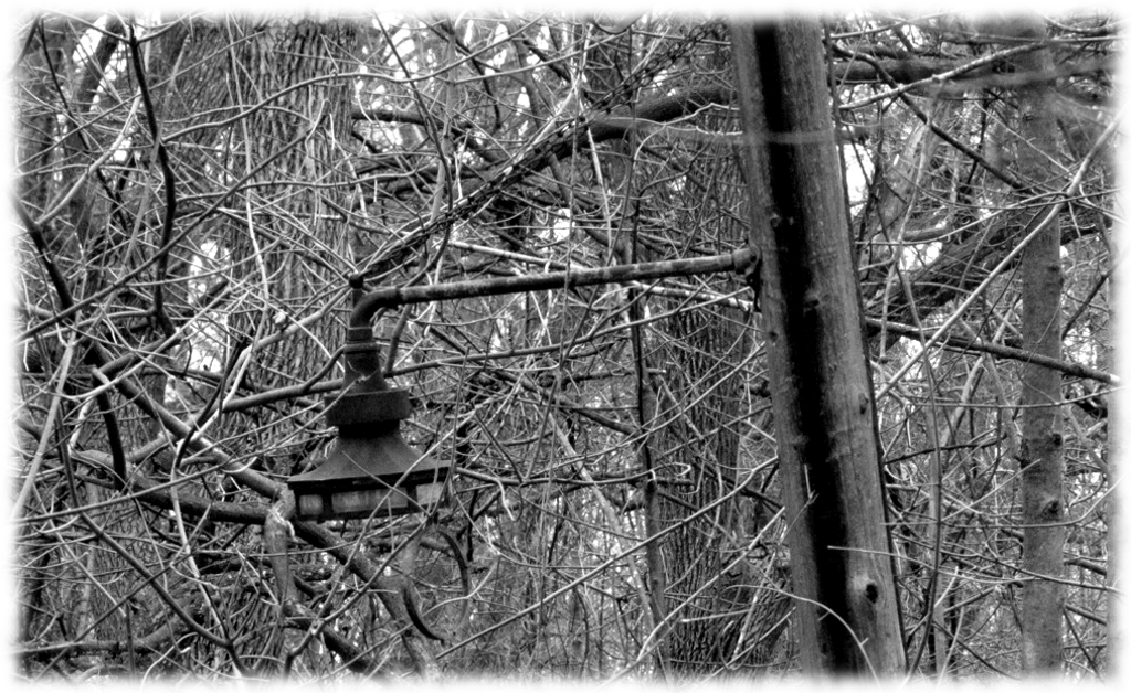
Did you know the wooded paths in Milwaukee’s Riverside Park were once illuminated? Some of the ornate century-old fixtures remain in place amid the trees. Carl Swanson photo
Once a natural ravine sloped down from Oakland Avenue to the Milwaukee River. In the 1890s, Frederick Law Olmstead’s famous landscape design firm used the ravine as the centerpiece of the future Riverside Park. The ravine is gone, but many aspects of the original park’s design remain – if you know where to look.
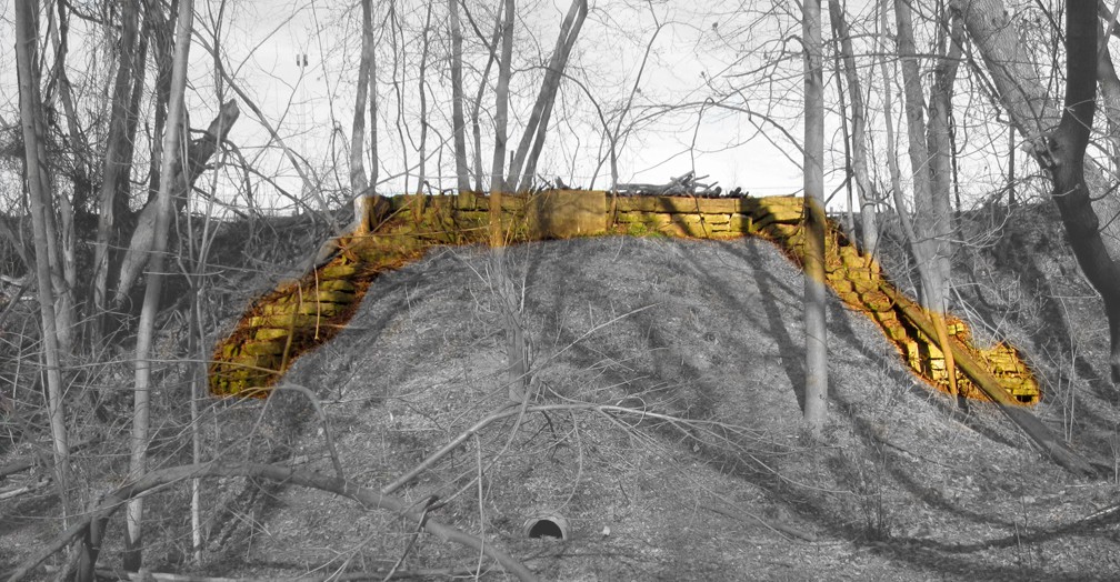
If you want to see what’s left of the old tunnel, now’s the time to do it. Summer plant growth makes the old tunnel difficult to see. The stone work is colorized in this early spring view. Carl Swanson photo

The tunnel looked very much like this. The postcard refers to a “Riverview Park,” a name shared by no Milwaukee park, leaving open the possibility this early 1900s photograph is actually a mislabeled view of Riverside Park. Carl Swanson collection
A carriageway was built from Oakland Avenue along the base of the wooded ravine, passing under the Chicago & North Western Ry. tracks (today’s Oak Leaf Trail) via a large tunnel made of massive limestone blocks. From there the road climbed to the top of the bluff and turned north to exit the park at Locust Street.
In the 1970s the ravine between Oakland and the C&NW mainline was filled in and became Riverside High School’s athletic fields. The tunnel was also filled in, although if you look carefully you can still find its stone arch facing the river.
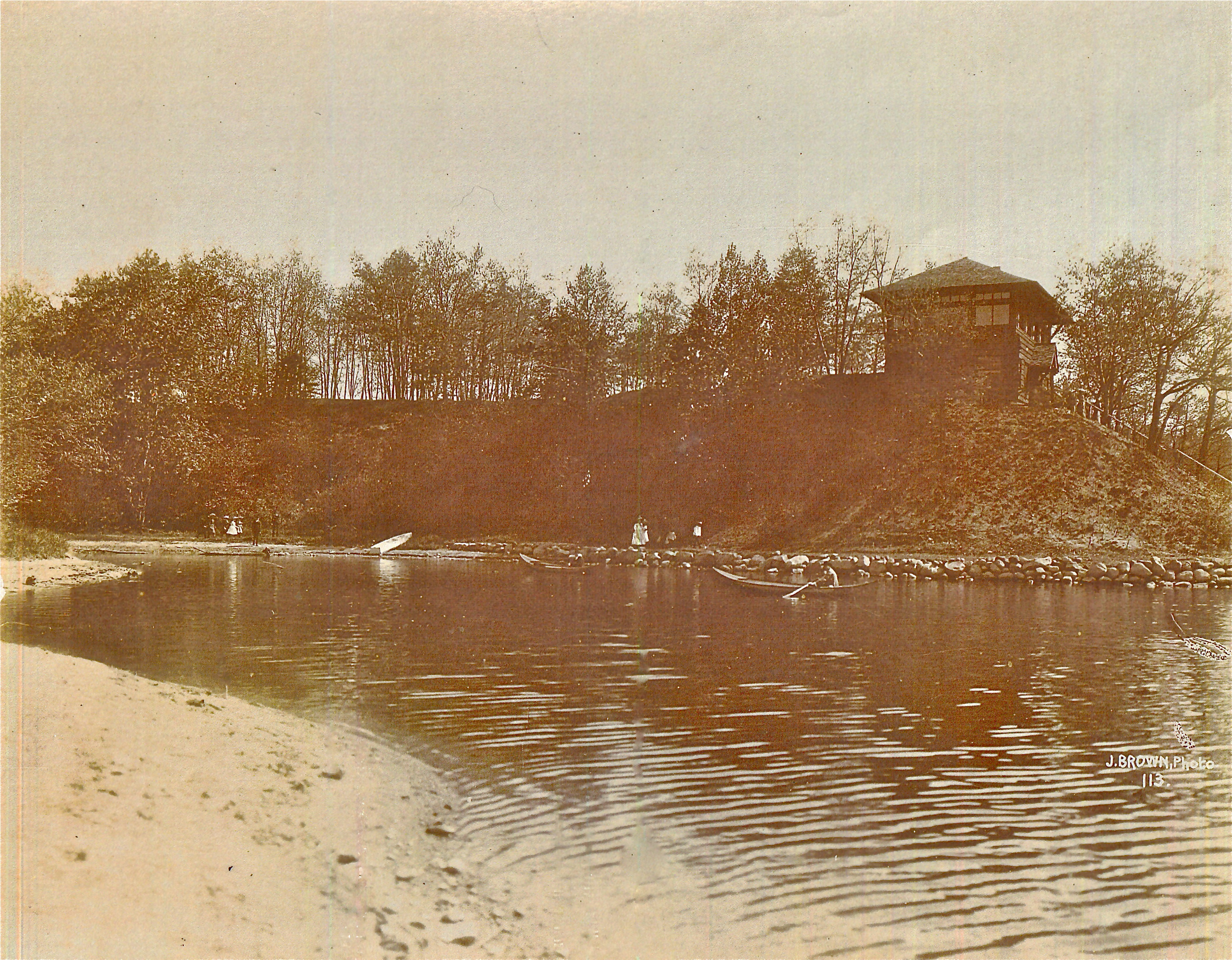
The park’s two-story pavilion stood on a hilltop with a flight of stairs leading down to the river. Courtesy Milwaukee County Historical Society
Long ago, the park’s wooded paths were illuminated at night and some of the ornate light fixtures remain in place amid the trees. Was the park board stung into action by this article from the July 31, 1915 edition of the Milwaukee Sentinel?
To a stranger in Milwaukee friends said: “You really ought to go out to Riverside Park some night when there is a band concert on. There are lots of canoes in the water, and I tell you it’s pretty.”
Now the stranger had seen some passably well trimmed craft, so he at once concluded that the sight offered in a large Milwaukee park would be one of great and unusual brilliance.
He boarded a streetcar Friday night for Riverside Park. Then followed an exciting hunt for the river, in the course of which he landed in a parking place for automobiles, a wire fence and climbed 51 stairs. At length he caught the sound of water lapping against the shore. Through the trees he saw the faint sheen of red, white and blue lights on the water, and whispered in ecstasy, “Japanese lanterns!” As he emerged from the undergrowth, however, he found the beautifully colored lights came from the reflection of an electric sign across the river.
It was all there – the soft, enchanting swish of the water against the keel, the low exclamations and pensive sighs, and an excellent band concert, but, ye shades of darkness, where was the light?

This postcard from around 1900 shows the Riverside pavilion on a hill overlooking the Milwaukee River. Stairs lead from the pavilion to a wide gravel path along the water’s edge. Carl Swanson collection

Once these stairs connected the riveredge pathway to Riverside Park’s pavilion. Carl Swanson photo
Light, as we’ve seen, was soon provided. The new fixtures lit the paths to the pavilion, which once stood on the edge of a steep bluff, at the top of a long flight of stairs leading down to a river-edge path along the Milwaukee River. The stairs are still there, but there’s no trace of the pavilion. Happily, this part of the river was popular with postcard publishers, and glimpses of the Riverside pavilion can be seen in several different postcard views from the early 1900s.
There are still questions I’d like to have answered. Whitney Gould’s “Spaces” column in the Feb. 2, 2003 edition of the Milwaukee Journal Sentinel refers to a waterfall and a sledding hill. Where were they located? For that matter, where was the curling club, which operated in the park, somewhere, from 1923 to 1970?
![]()

The sledding hill was located on the Eastern portion of the tract (now occupied by the athletic field). Riverside Place (originally South Park Front) ran across the crest of the hill and terminated at the footbridge. Residential blocks occupied the area to the South, and the hill descended to the North. The curling rink was West of the tracks along the Southern boundary (just West of the current fire ring).
LikeLike
Very helpful — thanks! It occurs to me now that there still is a small sledding hill at Riverside, just east of the Urban Ecology Center.
LikeLike
Camel’s hump. picked up cardboard from stores on Oakland and slid down the hill many times lots of memories from the 1950’s. Peeped in the curling building. never got caught. Toboggan slide was still there to but never got to experience that.
LikeLike
it would be awesome if them have were rhe created for New hikers and dog walkers and somehow them light fixtures or replicas can be repowered. We have a lot of historic places around here that no longer exists but there is always a plac sitting on that home site that says one stud so and so. I love the history and the discovery as well as the recovery. I am in California and my father is there. And by me doing the reading and research in him taking photos and experience in it. I feel like I am there in person. I have I have been born and raised in Milwaukee Wisconsin and have never known this and it intrigues me. The one thing about Monterey California is any historic place has a plaque a bowl or something that reminds you of once was. River Colony is something that people should definitely know about. It will keep the homeless out and it would clean the place up. all information is more than welcome. River colony should be a book. somebody somewhere has photos of them old houses.
LikeLiked by 1 person
I was once very familiar with this park, growing up west of the river and attending Riverside HS before the athletic field expansion. It was a nice place to walk during lunch hour. The tunnel gave easy access to the lower area of the park. A few times, I was there at night (late 60s), but can’t say for certain if the lighting was working.
LikeLike
Thanks for the additional information!
LikeLike
Light fixtures in the park are cousins of the Milwaukee harp lamp fixtures, and your photos clearly show that these were the early style, which had narrow stained glass panels in the metal frame above the globe. Later fixtures had the glass replaced with a solid metal panel. The early fixtures were cast iron, and later versions were cast aluminum.
LikeLike
I lived in the 2700 block of N. Bartlett Ave. from 1942 to 1962 (ages 8 to 28). Riverside Park was a major part of my growing up including baseball, softball and the playground equipment in the summer and sledding on Devil’s Hill and walking through the park to the icy Milw. River in the winter. I even remember the tobaggan slide just west of the curling rink west of the tracks along with the Chicago, Northwestern ‘400’ train as it ran right through the middle of the park.
Mike Barron
LikeLike
Hi Mike, I also remember the park and all its fun. Your neighbor Thelma Kamuchey!!!!!!!
LikeLike
You can still see traces of the curling club foundation.
LikeLike
Very interesting article. I grew up in the 2600 block of North Newhall Street in the 60’s.
I spent my entire childhood playing in and exploring Riverside park.
The other side of the park across the tracks I remember the curling rink, the toboggan slide and an old crumbling former factory type building on the south end down towards the river, loved to crawl around through it.
I Sledded the hills in the winter and in summer walked through the park on my way to Gordon pool.
Many happy memories.
Always wondered what those stairs to the river were.
BTW, I found an 1898 street map of Milwaukee and Riverside Park was named “River Park” at that time.
LikeLike
My cousin who lived just up the street on Oakland and I used to play in Riverside Park many, many Summer days, 1961-1963. It would be easier to show you where the curling club was than to describe it. At the extreme south end of the park’s perimeter there is a pedestrian bridge that went over the railroad right of way (that is now garden plots). That pedestrian bridge was in extreme disrepair when I saw it a few years back, with tons of grafitti and trash underneath. The curling club was just over it, on the east side of the pedestrian bridge and to the left, to the south. It always seemed to be closed when we passed it. There was a paved alley or ministreet that connected with the industrial buildings to the south, and a particular moving van than never moved. In that direction, at one point, was the Cornell Paper Company, which was largely destroyed in a humongous conflagration during that era. We watched it burn from the Humbolt Ave. viaduct, all praying for my uncle who was a fireman. When I visited the park for the first time in decades, it had changed so much that I could really not find my bearings. We used to enter the area adjacent to the River through an old tunnel that I could not recently locate, and a gravel path led to it. We used to play Army charging down the hills on the north side of that path. Where now there are woods and hills, my recollection is that there was a well-maintained grass lawn adjacent to the River, where we used to look up to the underside of the Capitol Drive bridge.The entire geography of the Park is massively changed in a vertical direction, and it would not surprise me to learn that this is where some of the earth that was excavated to run the North South Freeway may have been dumped here (along with that dumped to build the McKinley Marina) to create hills where there was flat land before.
LikeLike
We played baseball on acorn hill thru out the 40s…..south end of acorn hill stood the curling club which was immediately adjacent to a paint factory that burned down (also in the 40s)In the 50s we were finally allowed to play baseball in the roped off rink boundrd by oakland to the east and geneva and riverside place to the north and south.We also played strike out using a chalk box square on the south sid e of the service bldg.There were swing sets ,teeter tottoers .a slide and swing rings and 2 sand boxes.We were watched over by Tony the park man…..a really good guy.We al;l swam in the river….and had to keep an eye out for the s.s.kill joy,the police boat that patrolled the river.It was a refuge for all of us back then.
LikeLike
I lived on Murray Ave. from 1962 to 1972 and we used to sled down the hill. If you did it just right, you could hang a left at the bottom of the hill and finish in the tunnel.
LikeLike