Milwaukee County Parks

A bridge by any other name …

A photograph showing the north end of the Pleasant Valley box culvert.
The site of a famous Milwaukee River beer garden at the turn of the last century, the only structure in Pleasant Valley Park today resembles a pedestrian bridge, but it actually has a much different function. Carl Swanson photo.

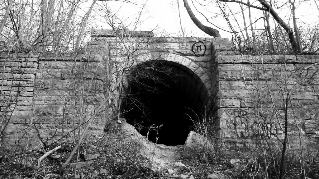
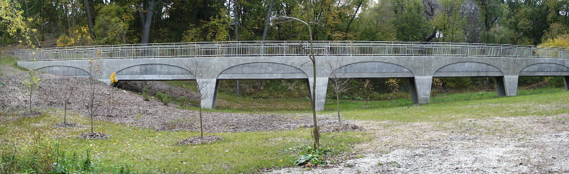
Pleasant Valley Park, located on the west bank of the Milwaukee River south of Kern Park, contains a mystery. The only manmade structure in the undeveloped and heavily overgrown county park is a 250-foot-long pedestrian bridge emerging from a sloping hill, crossing a valley, and ending at the opposite wall of the ravine. No developed trails lead to it, although walkers have worn meandering paths to and from the structure. 

It’s solidly built and impressively large – and it also seemingly serves no purpose. Why is it there?

I was recently contacted by WUWM Milwaukee Public Radio’s Bubbler Talk program, which was seeking the answer to a listener’s question, “Why is there a large bridge in the middle of the woods by the river in Riverwest that goes nowhere? Is it a remnant of Blatz Park?”

Blatz Park, originally called Pleasant Valley when it opened in 1870, was a popular beer garden at the turn of the last century. It featured a restaurant pavilion, live music, and extensive and beautifully maintained grounds. It was served by shallow-draft steamboats operating from a dock near the North Avenue bridge. A roundtrip was 15 cents and included stops at Wonderland Amusement Park in Shorewood and the beer garden in Pleasant Valley.

The park closed after World War I, a victim of changing tastes in entertainment and the rise of the private automobile. A swimming school briefly took its place until it, too, closed. In the 1920s, the land was sold to Milwaukee County by the Blatz family to facilitate the construction of a planned roadway along the river. The road was never built, and the land was handed over to the Milwaukee County Parks System.

Read about Pleasant Valley’s beer garden days.

Apart from a few concrete footings near the river, nothing remains of Blatz Park today and the mysterious structure is of far newer construction.

A photograph showing a side view of the concrete box culvert in Pleasant Valley Park, Milwaukee
Why was this bridge deep in the woods south of Kern Park? The answer is simple. It’s not a bridge at all. Carl Swanson photo

That gets us back to the original question. What the heck is this thing in the woods? Its thick, square cross-section suggests an enclosed aqueduct – a bridge for carrying water across a valley.

At first, I thought it might be a water main. After all, the structure is just north of the Riverside Pumping Station, which distributes fresh water from the treatment plant on the lake throughout this section of the city.

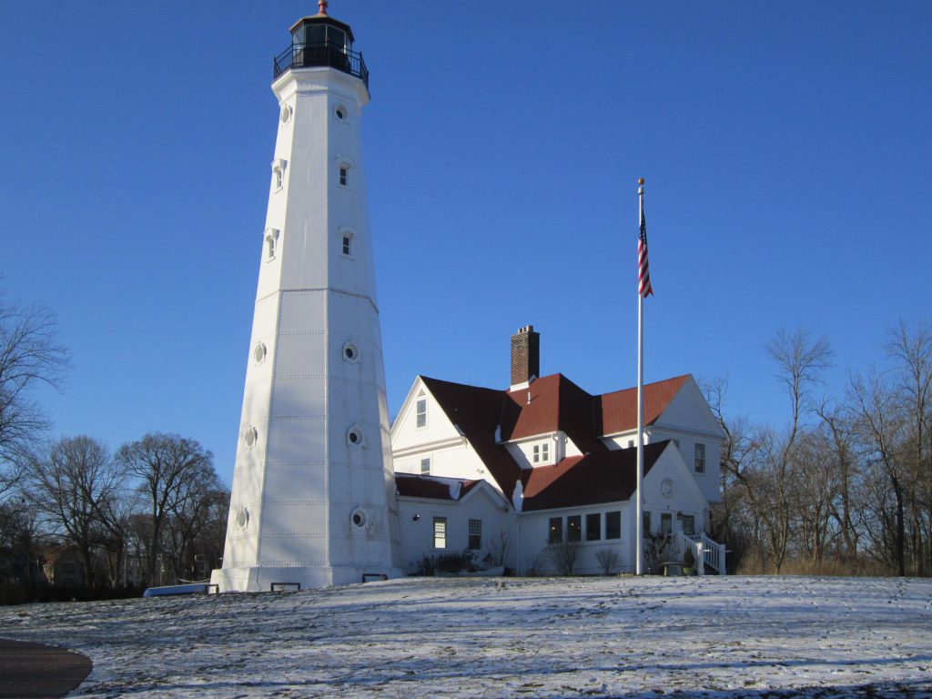
Read about the historic Riverside Pumping Station.

As I tried to get usable photos of this bridge/aqueduct/box culvert/alien artifact/whatever – no easy task given the thick woods – I noticed the covers of nearby manholes were lettered “sewer”.

I contacted the Milwaukee Metropolitan Sewerage District (MMSD) and asked if the bridge belonged to them. Keith Kalinger, Senior Project Manager, replied, “It’s actually a 60-inch sanitary sewer that transports flow south to the Jones Island Water Reclamation Facility. The current aqueduct was constructed in 1999 to replace an existing one whose plans date from 1918.”

He added, “It’s not even our only aqueduct. There is another one in Estabrook Park along the walking trail that starts near Capitol Drive.”

A photo showing the cast-in concrete arch detail in the Pleasant Valley sewer culvert.
Built in 1999, the box culvert was designed with tapered concrete legs that flow into cast-in arch shapes – graceful touches for a sewer line in a seldom-visited part of Pleasant Valley Park. Carl Swanson photo

Rather than a bridge to nowhere, the aqueduct is a sensible response to challenging topography. It’s more cost-effective to run the line across an elevated structure than bury the pipe deep enough to go under the ravine in Pleasant Valley Park. Applied Technologies, the designer of the 1999 project, and Lunda Construction, its builder, gave some thought to its appearance. Tapered supporting legs flow into arches cast into the concrete surface. They also added stainless steel safety railings along the top to create an inviting walkway. The whole thing cost a half-million dollars in 1999. Pretty snazzy sewer!

We don’t often think of sewers. If they come to our notice at all it’s because something horrible is happening. Hidden and largely ignored, they are absolutely vital to the city’s wellbeing. Consider this glimpse of life before sewers from Orlando Wright, the city’s Commissioner of Health, who reported in 1879:

Sometimes, in a dry season, the sewage of Milwaukee nearly equals the quantity of water flowing in the rivers. At least 100 tons of human and animal excreta, to say nothing of other putrescible organic matters, are emptied into these sluggish streams every day. Their waters are dark with filth, and yet the question is asked whether they are unhealthy. If a thick solution of ordure is unhealthy, the Milwaukee and Menomonee rivers are certainly so.

First Annual Report of the Commission of Health of Milwaukee, January 1879

The sewer mains running along both banks of the Milwaukee River, intercepting wastewater and diverting it for treatment, were built in response to these intolerable conditions and are a major reason the river today is in a far cleaner and healthier state than it was in Milwaukee’s formative years.

Thanks to Kathryn M. Schmitt, MMSD contract compliance administrator, for her assistance with this article.

A panoramic view of the aqueduct from October 2000 shows tidy landscaping and small trees.
The Pleasant Valley aqueduct, as it appeared in October 2000 shortly after its completion. Photo courtesy MMSD

Interested in learning more about Milwaukee’s fascinating (and occasionally odd) history? Check out my book. (Paid link)


Advertisement

The forgotten Milwaukee River park

Pleasant Valley Park on the west bank of the Milwaukee River was once one of the city's most popular beer gardens. Owned by the Blatz brewery and visited by thousands, it featured elaborate landscaping, a restuarant, bandshell, pavilion, steamboat dock, and even a few cottages. In 2014, little remains to remind visitors of its glory days a century ago. Photo by Carl Swanson

Pleasant Valley Park on the west bank of the Milwaukee River was once one of the city’s most popular beer gardens. Owned by the Blatz brewery and visited by thousands, it featured elaborate landscaping, a restuarant, bandshell, pavilion, steamboat dock, and even a few cottages. Little remains to remind visitors of its glory days a century ago. Photo by Carl Swanson

Pleasant Valley Park, at the foot of East Concordia Avenue on the Milwaukee River, is a peaceful place. The band packed up and left a century ago, about the time the steamboats stopped calling at the park’s dock. A little later, the pavilion, pier, cottages, and bandshell were torn down and the rubble removed. Officially this is a Milwaukee County Park but you wouldn’t know it by looking at it. There are no signs, no parking area, no picnic benches or ball fields, nothing at all to suggest it had ever been anything other than a ravine filled with downed trees and garlic mustard.

But once this was one of Milwaukee’s best-known beer gardens:

“Blatz Park (“Pleasant Valley” before 1892) swarmed with picnickers in those days. Troops of large families from St. Casimir’s Parish, a mile south, regularly followed a makeshift marching band up Humboldt Avenue to the park, each family pulling a coaster wagon containing a picnic lunch. Steam-powered boats, sailing from a dock just above the North Avenue dam, pulled up periodically at the pier and discharged crowds of passengers. The park had a bandshell and later a restaurant. There were also cottages, often rented in the summer, by one account, to actors from a theatre downtown.” – From Riverwest: A Community History, by Tom Tolan, copyright 2003, Past Press, Milwaukee, WI.

(more…)

The Lady and the Light

For 33 years, starting in 1874, the operation of the North Point Lighthouse in Lake Park was in the capable hands of an extraordinary woman. Photo by Carl Swanson

If you visit the old lighthouse in Lake Park you will hear the surprising story of Georgia A. Stebbins, keeper of the North Point light for 33 years starting in 1874.

To put that in perspective notes the lighthouse website, it would be another 46 years before women were allowed to vote. Yet here was Georgia, duly appointed by the federal government and in sole charge of a vitally important maritime safety facility.

(more…)

East Side tunnel to nowhere

Built more than a century ago, this stone tunnel portal in the east bluff of the Milwaukee River is near the intersection of North Cambridge Avenue and Hampshire Street. Partly filled in and heavily vandalized, it remains impressive — and mysterious. Carl A. Swanson photo

There is a mystery in Cambridge Woods Park on the east bank of the Milwaukee River — an ancient tunnel made from carefully cut and fitted stone blocks and large enough to drive a truck through.

From its portal in a bluff at the foot of Hampshire Street, the tunnel extends eastward under the Oak Leaf Trail only to end abruptly at a modern concrete wall about 60 feet inside the entrance.

Who built it? And for what purpose?  (more…)

Cracker-Jacks Park was a river landmark

Cracker_jack_cart

A shopping cart at the north end of Richards Street marks the former location of Cracker-Jacks Park. This once-popular privately owned picnic grounds on the west bank of the Milwaukee River is nearly forgotten today. Carl A. Swanson photo

On the Fourth of July, 1938, two sisters, ages 6 and 12, seeking a spot to watch the Estabrook Park fireworks from the west bank of the Milwaukee River found trouble instead. As they approached the bluff, an adult male emerged from the bushes, slapped the 6-year-old twice across the face, picked her up, and carried her off down a ravine.

Fortunately, help was nearby. Henry Kaeding, a resident of the 4200 block of North Richards Street, came running at the sound of the older girl’s screams and charged into the ravine in pursuit of the abducted child and her assailant.
(more…)

Red Arrow: The park that moved

"Red Arrow" division insignia

Since the 1920s, Milwaukee has had a park dedicated to local soldiers who fought with the 32nd Red Arrow division of the U.S. Army. The 8-foot-tall divisional insignia was added in 1984. Carl Swanson photo

Milwaukee has always considered park names open to change. The strip of greenery in the median in front of Central Library, for instance, was once Washington Park. The present-day Washington Park was originally West Park. Pere Marquette Park is along the downtown riverfront, formerly it was several blocks south and in front of the Milwaukee Road station. The station is gone, but there is still a park – now called Zeidler Union Square.

And then there is the strange history of Red Arrow Park.

(more…)

The top 5 posts of 2015

Gordonbathhouse_1914-1

The Gordon Park bathing pavilion was the most popular blog post for the second year running. Photo by Jos. Brown.

Thank you for a great year in 2015! This blog was viewed 29,000 times in the past year. In 2015, 43 new posts were added to the site (for a total of 90) and 378 pictures uploaded, about a picture per day.

These are the top five posts of 2015. Have you read them all?

  1. Amid the ruins of Gordon Park’s riverside bathing pavilion
  2. Secrets of Shorewood’s Hubbard Park
  3. Just a neighborhood movie theater
  4. Drinking Pabst in Whitefish Bay
  5. Sunk, burned, and haunted, this tugboat keeps on working

Much more is on the way in 2016 —stay tuned!Carl_sig

Surprising facts about Milwaukee

Also zombie-proof. Carl Swanson photo

We can still water our lawns after a nuclear war

The North Point pumping station was built in the early 1960s with roof and walls two-feet-thick to protect the city’s vital water pumps from a nuclear blast. Arthur Rynders, superintendent of waterworks at the time, felt this was a reasonable precaution because survivors of World War III would need water to fight fires and “to wash atomic contamination into the sewers.” Source: The Milwaukee Journal, Aug. 11, 1960


(more…)

The past haunts Riverside Park

Did you know the wooded paths in Milwaukee's Riverside Park were once illuminated? Some of the ornate century-old fixtures remain in place amid the trees. Carl Swanson photo

Did you know the wooded paths in Milwaukee’s Riverside Park were once illuminated? Some of the ornate century-old fixtures remain in place amid the trees. Carl Swanson photo

Once a natural ravine sloped down from Oakland Avenue to the Milwaukee River. In the 1890s, Frederick Law Olmstead’s famous landscape design firm used the ravine as the centerpiece of the future Riverside Park. The ravine is gone, but many aspects of the original park’s design remain – if you know where to look.

(more…)

Revisiting Kern Park’s “Lover’s Lane”

This early 1900s postcard shows Milwaukee's "Lover's Lane." Carl Swanson collection

This early 1900s postcard shows Milwaukee’s “Lover’s Lane.” Carl Swanson collection

An antique postcard adds a fresh perspective to a post from last year on the end of Kern Park’s “Lover’s Lane.” Read it here.Carl_sig