
Built more than a century ago, this stone tunnel portal in the east bluff of the Milwaukee River is near the intersection of North Cambridge Avenue and Hampshire Street. Partly filled in and heavily vandalized, it remains impressive — and mysterious. Carl A. Swanson photo
There is a mystery in Cambridge Woods Park on the east bank of the Milwaukee River — an ancient tunnel made from carefully cut and fitted stone blocks and large enough to drive a truck through.
From its portal in a bluff at the foot of Hampshire Street, the tunnel extends eastward under the Oak Leaf Trail only to end abruptly at a modern concrete wall about 60 feet inside the entrance.
Who built it? And for what purpose?
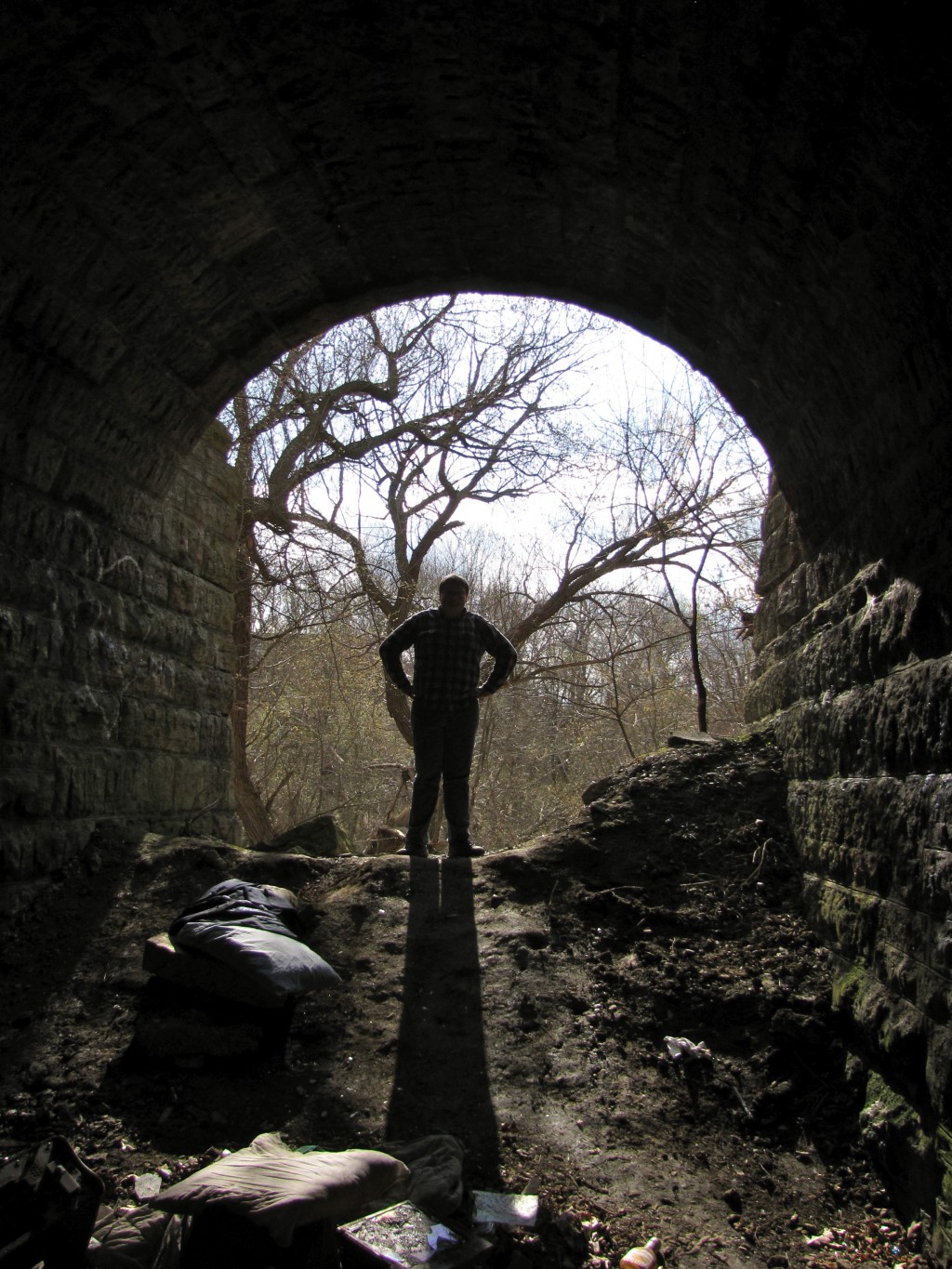
John Swanson stands at the partially filled-in tunnel entrance. Carl A. Swanson photo
The first question is easy to answer. The second is more elusive.
In the 1880s, the Northwestern Union Railway built a railroad line from the downtown lakefront north through the East Side and Shorewood. Workers cut through hills and filled ravines as they went.
At Riverside Park, the railroad contractor built a stone-lined tunnel underpass to accommodate a carriage drive, which then ran from Newberry Boulevard to the river.
That tunnel was filled in when the Riverside High School athletic field was built in the 1970s, but you can still find traces — if you know where to look.
Further to the north, the railway built two stone tunnels and filled a deep ravine at Shorewood. One tunnel served a creek that drained to the Milwaukee River and the other provided wagon access for an ice harvesting business in what is today Hubbard Park.
The ice operation is long gone, so is the creek, and so, for that matter, is the railroad. (Its former right-of-way is now the Oak Leaf recreational trail.) But the twin tunnels at Hubbard Park, now used by roadways, are still there.
These tunnels are railroad underpasses. They were probably built first and later covered by the fill dirt of the railroad embankment — no tunneling required.

The tunnel interior, strewn with trash and marked with graffiti, extends about 60 feet under the Oak Leaf Train and ends at a modern concrete wall. Carl A. Swanson photo
But what of the crumbling remnant in Cambridge Woods? It appears to extend deep into the bluff with no apparent eastern portal. Where did it come out?
When the railroad came through, 130 years ago, Hampshire Street and the surrounding residential neighborhood was still in the future. Most likely, in the 1800s, this was the location of a ravine cutting through the bluff down to the river. Years later, that ravine east of the tracks was filled, leveled, and divided into lots for homes.
The question of why the railroad built this expensive piece of civil engineering remains.
Perhaps there was once a creek, like the one formerly flowing through one of the Hubbard Park tunnels. But I think it is more likely this tunnel provided access to another river ice harvesting operation.
According to the 1879 annual report of the Commissioner of Health of Milwaukee, “The Joseph Schlitz Brewing Company erected five large ice houses on the west bank of the Milwaukee River, about midway between North street bridge and Humboldt (now Capitol Drive), where it will cut a supply of ice sufficient for the requirements of its extensive brewery and bottling establishment.”
As part of this effort, the brewery built a log dam across the river at the foot of East Chambers Street and, on the west side of the river built two large ice houses. This operation was active at the time the railroad was under construction.
The brewery also owned the land on the east bank of the river. In fact, this part of Cambridge Woods Park was donated to the county in 1940 by the owners of the brewery.
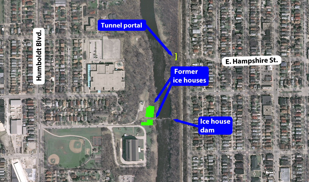
At the time the tunnel was built in the 1890s, the land on both sides of the river was owned by the Schlitz Brewing Co. and used by its ice harvesting operations.
In its November 26, 1940, issue, the Milwaukee Journal announced the donation. Included was a parcel between the river and the railroad tracks running from the tunnel north to East Edgewood Avenue. The 2,282-foot-long, eight-acre parcel varied between 150 to 258 feet wide. The newspaper said it was “wholly unproductive property” but ideal for park purposes.
It seems probable the brewery, back in the 1890s, demanded railroad contractors build the underpass to provide access to the Schlitz-owned land on the east side of the river. Did the brewery also maintain an ice house on that side of the river?
Crumbling, partially filled in, but still imposing, the tunnel guards its secrets.
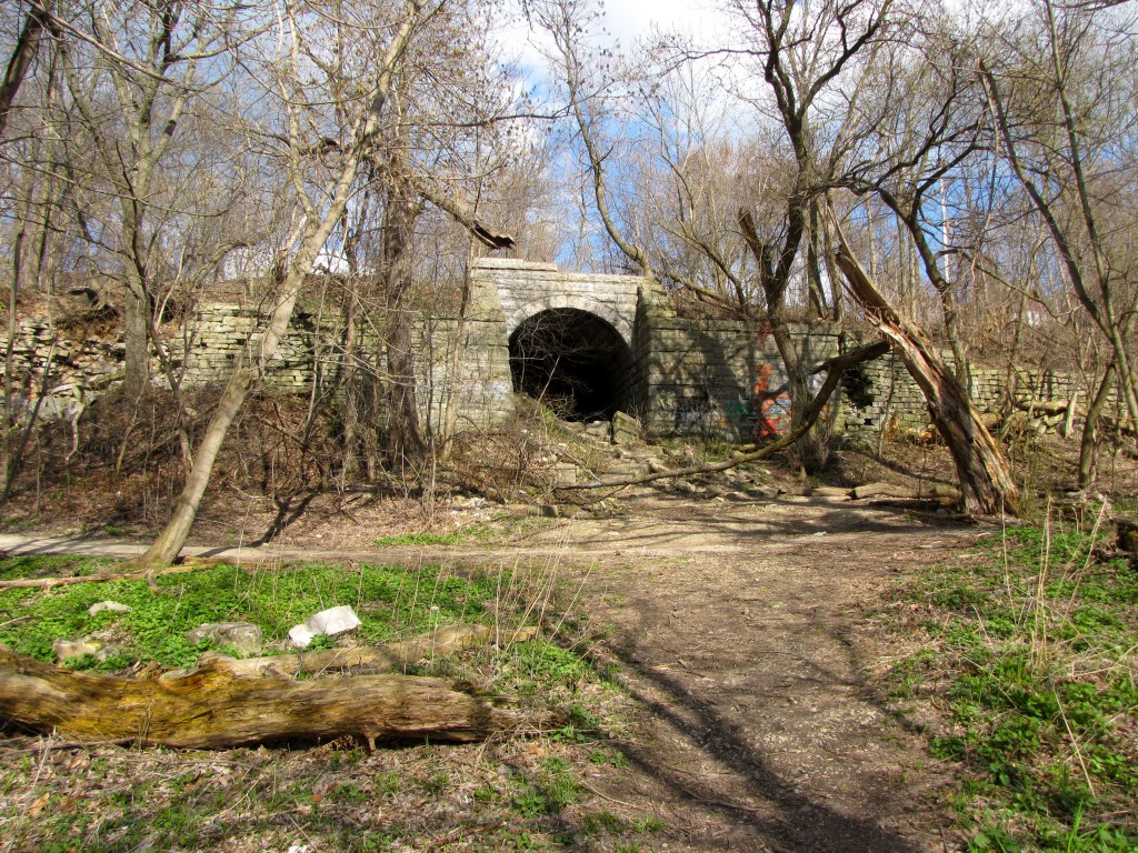
The west portal of the railroad underpass tunnel at the foot of East Hampshire Avenue is a striking example of the stonemason’s craft. Photo by Carl Swanson
![]()

Thanks for the investigation! Despite living in Riverwest and attending RHS, I never knew about this underpass.
LikeLike
Appreciate the comment! I’ve been looking around for information on this thing for a couple of years and still don’t know exactly what purpose it served!
LikeLike
I think there is a clue visible in the air photo… the shape of E. Hampshire St. itself. Notice how it takes a jog from it’s “regular” position, parallel to the other east-west streets. But at Newhall St. it takes a jog to the north, for no apparent reason. Except… to line up with that tunnel.
LikeLike
Good point — hard to think of any other reason Hampshire shifts at that point. Thanks!
LikeLike
Little known fact but related: the ‘River Colony’ was a group of houses situated along the east bank, north of Locust Street. I believe they existed until the 1950’s but they had access to their homes only by this tunnel and stairs off of Locust Street.
LikeLiked by 1 person
Thank you for posting. I love reading about the history of Milwaukee!
LikeLiked by 1 person
I love researching Milwaukee history. Especially the old plank trails that led in and out of the city.
Also, the pre-history of the native Americans that occupied this area for thousands of years.
LikeLike
As a kid, that tunnel was the center of my friends and my world. I lived on Bartlett Avenue just south of E. Kenwood Blvd. from when I was born in 1938 until 1952. We used to swim in the river near the tunnel and would be chased away by the MPD Chris Craft which patrolled the river between the North Avenue Dam and Hubbard Park. They had a boathouse on the river at Gordon Park. Many great memories.
LikeLike
There used to be an amusement park in this area that had roller coasters and what not. The tunnels could have been used by them
LikeLike
Wonderland Park (?) was a bit further north, between the railroad tracks and Oakland Avenue at Edgewood Ave. Carl wrote about it a few years ago.
https://milwaukeenotebook.com/2014/12/02/history-of-shorewood-hubbard-park/
LikeLike
It’s possible that the tunnel was built to provide general access to the river for recreation, including the rowing clubs. At least one of the Downer College clubhouses was located directly in front of the tunnel. It also seems to relate to the 13 small riverfront houses between Kenwood and Locust. If property records exist for any of these structures, you may be able to determine whether they predate the railroad.
LikeLike
Marc, I think you are on the right track. A 1921 section map (which, unfortunately, ends just south of the tunnel) shows north of the River Colony neighborhood as owned by Downer College. Thanks!
LikeLike
Some of the locals call it Elephant Tunnel. not sure why but it was a fun adventure place for us kids and I still visitto this day. Great post ! Thanks !
LikeLike
How about the roller skating place under the east side of the north ave. bridge and above the
dam (gone now) a large building that was an old swimming club (according to some old timers) and I believe had a sign; ” Balfors Towing”…??? …Played in those woods from
certainly the cave to sledding in Estabrook park south of the Kilbourntown house…Remember
the Pig and Whistle only sold custard…no food…and you could watch the big machine making
the custard through the window……..a few years ago…!
LikeLike
Used to walk through the WOODS. sneak across the tracks from where we lived on Cambridge and go the back way to hang out in Hubbard Park. was a nasty fence around the tunnel before the park. remember hanging off to get around it. better in winter just walk on the ice on the river.
LikeLike